
 |
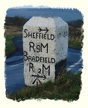
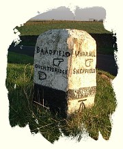
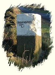
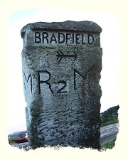
In the Middle Ages the power of the Church and the monasteries helped travellers in the more lonely parts of Britain to find their way. The monastic landowners erected crosses, sometimes to define their boundaries but often to indicate the way. Few of these have survived the ravages of Time, and from the Dissolution of the monasteries in the late 1530's until the advent of the Ordnance Survey three hundred years later travellers had to orient themselves using local knowledge - either their own or hired guides. In the more remote areas of England, particularly the Peak District and the Yorkshire moors many travellers perished when they lost their way or the weather closed in and they became disoriented as reference points were obscured. The ancient practices of erecting markstones, cairns and other waymarkers was formalised in 1697. William III passed an Act decreeing that in the more remote parts of the kingdom, where two or more paths intersected, local Surveyors were to erect guide stones showing the way to the nearest market town. These stones predated the advent of the turnpike roads, and because the project was not properly funded, there was considerable variation in the enforcement of this ruling across the country. The parish of Bradfield, near Sheffield, has a lot of these which are grade II listed - they served travellers who were about to embark on the journey across the Peak District moors. References |
 |
||||||||||||||||||||||||||||||||||||||||||||||||||||||||||||||||||||||||||||||||||||
 |
index of stones by county | Guestbook
|
 |